

This High-Tech Backpack Is Mapping the Remotest Corners for Google (Video)
Most people know about the fleet of Google cars that go around filming streets.
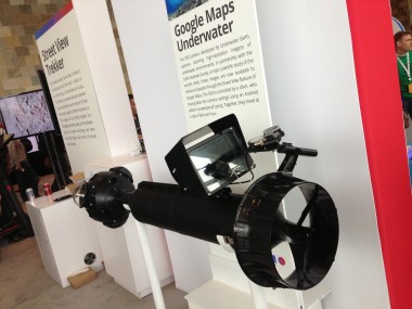
But what about the submarines and the tricycles and the backpacks? At Google I/O this week, the company showed off the collection of off-road gear it uses to map the places the cars can’t go.
One of the latest additions to Google’s arsenal is a 42-pound backpack equipped with 15 cameras that takes a picture every 2.5 seconds as a hiker lugs it up a mountain, along a trail or through narrow streets unreachable by other means.
So far, Google has used it to map the Grand Canyon and remote areas from Brazil to the Arctic to Venice, Italy.
At I/O, Google hooked the footage taken with the backpack to three monitors connected to a treadmill. As attendees walked along the treadmill a new image would pop up for every few meters covered.
In a video interview, Steve Silverman, program manager for Google Maps, talked about the effort.
RELATED POSTS:
- Shoot the Moon: How Google Turned a Hodgepodge of Upgrades Into a Show of Strength
- Google I/O: Music, Maps, Messaging and More
- Larry Page Takes the Pulpit to Praise Technology, Snipe at Competitors
- Next Google Maps Update to Include Better Venue Search, Waze-Like Rerouting
- Google Gives Search a Deeper Voice and Adds Reminders and More to Google Now
- With Revamped Hangouts, Google Aims to Unify Messaging
- Google+ Gets a Bit More Pinteresting
- Google Chrome: 750 Million Active Users, Synchronized Web and Mobile Browsing
- Coming Soon From Google: A $649 Samsung Galaxy S4 Running Stock Android
- With Sights Set on Spotify (And Pandora), Google Launches a Music Subscription Service
- Google on Android: 900 Million Activations, New Tools for Developers Coming
- Google Doubles Down on Music Subscriptions, Which Means Google Isn’t Serious About Music Subscriptions
- Where Are They Now? Google I/O 2012 Edition.
- At I/O, Google Tilts Toward Android Services Over Android OS
- Google Downplays Expectations Ahead of I/O Developer Conference
- Will Google Deliver on Its Nexus Q Promise? Not at This Year’s I/O.
- Ahead of I/O, Google Wallet Drops Plans to Introduce a Physical Card
- Google Goes With Unified I/O Keynote (But Will It Unify Its Products?)


